Goat Town, Georgia

Goat Town, Ga.
Goat Town, Ga.

Better South President Andy Brack remembers seeing the “Goat Man” as a boy when in the back seat of a station wagon traveling between his father’s country cousins in Allentown, Ga., to nearby Macon, where his grandparents lived.  You’d see him pushing a wagon filled with all sorts of junk.  He was, in a word, a “character.”

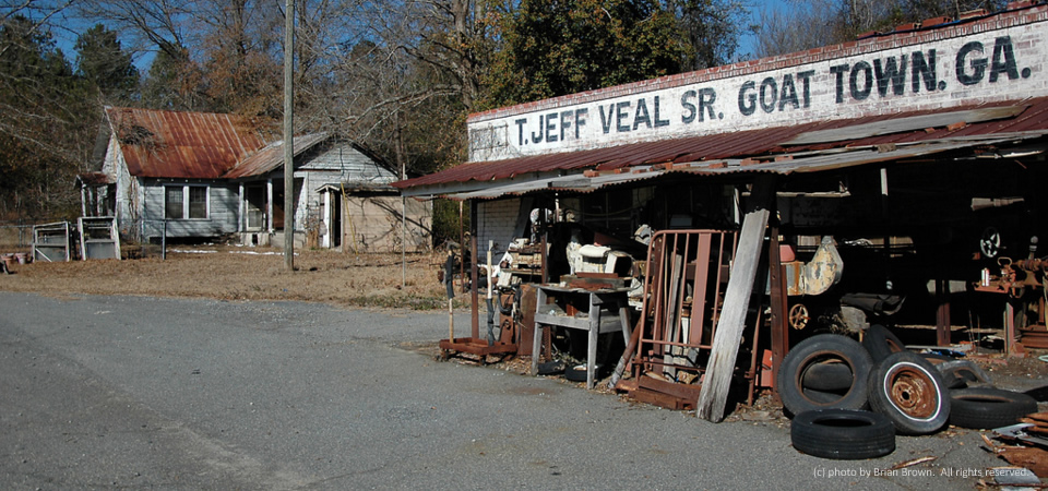
VanishingSouthGeorgia.com photographer Brian Brown has this to say about the photo he took in 2013 of the odd Washington County landmark:  “Goat Town isn’t really a town and it never was, though you can locate it on a good map. It’s just down the hill from Deepstep, whose iconic old store is also associated with the Veal family. T. Jeff Veal III, who uses his grandfather’s old country store as a workshop to build custom furniture, explained to me that a large herd of goats was kept around the corner in years gone by and the name just stuck. I’ve been here a couple of times and it never ceases to amaze me; it’s widely popular with Georgia’s backroads photographers.”
Photo is copyrighted by Brian Brown.  All rights reserved.

Grand old house, Orangeburg County, S.C.

Grand old house, near Holly Hill, S.C.

We’re still trying to find out the history behind this grand house about five miles northwest of Holly Hill, S.C. where U.S. Highways 15 and 176 split.  We’re told a family that just had a daughter (see if you can find the pink stork sign) is renovating it slowly.  [We shared this popular photo first in 2013 and thought you’d like to see it again.]

UPDATE, 9/27/14:  Our friend Lynn Teague of Columbia says her kin and friends call this the old Galphin House.  Later she sent word that archives in Orangeburg identify the house as being built by the Rev. Richard Powers Galphin and Lillian Wells Galphin, who died in 1913 and 1935 respectively.  She added that the land around Wells Crossroads likely belonged to the Taylor family more than 200 years ago.  Thanks Lynn!

Holly Hill, which had about 1,300 people in 2000, is near the Santee Cooper lakes in Orangeburg County as well as Interstates 26 and 95.  Thirteen miles south is the National Audubon society’s Francis Beidler Forest in Four Holes Swamp.  It features the largest remaining stand of virgin bald cypress and tupelo gum swamp in the world.  Also a few miles from Holly Hill are two large cement quarries.

Holly Hill is just one of the many towns in Orangeburg County, South Carolina’s largest.  Some 91,476 people were thought to live in the county in 2012, according to the U.S. Census.  Almost two in three residents are black.  Some 24.5 percent of residents live below poverty.

Photo is copyright 2013, Andy Brack.  All rights reserved.

Old GMC truck fades away in Florence County, S.C.

This old GMC truck, despite its coat of rust, still has plenty of character as it sits beside U.S. Highway 52 in Florence County, notes Kingstree, S.C., photographer Linda W. Brown.

Florence Countyhad 137,948 people, according to a 2012 Census estimate.  Its poverty rate — higher in the rural areas than the county seat of Florence, averaged 19.4 percent in 2010.

Copyrighted photo by Linda W. Brown.  All rights reserved.

Store, Jordan, Ga.

Tiny store, Wheeler County, Ga.

This store, which VanishingSouthGeorgia.com photographer Brian Brown writes is about all that’s left in the settlement of Jordan in rural Wheeler County, Ga., looks remarkably similar to a building pictured here in Orangeburg County, S.C., more than 200 miles away.

According to 2011 poverty estimates by the U.S. Census, Wheeler County, which had 7,421 people in 2010, had a 42.2 percent poverty rate.  What’s remarkable about that is it is one of the few high-poverty counties where the overall rate is higher than the rate for children under 18.

About two thirds of the residents of the south-central Georgia county are white with the remaining almost all black.

Copyrighted photo taken in March 2014 by Brian Brown.  All rights reserved.

Red field, near Kingstree, S.C.

Field of sorrel, Clarendon County, S.C.
Field of sorrel, Williamsburg County, S.C.

By springtime, most agricultural fields once were under cultivation, writes retired editor Linda W. Brown of Kingstree, S.C.  But this Williamsburg County field near Kingstree has been taken over by common sorrel, an herb often viewed as a weed with small bright red to purple flowers.  “The changing agricultural outlook leaves many of them [fields] fallow,” she writes.

Williamsburg County, which is about 75 miles north of Charleston, S.C., has a population of just under 34,000 people.  Population peaked in 1950 at 43,807, but has dropped slowly since then.

About two-thirds of county residents are black, with almost  all of those remaining being white.  Only 2 percent of those in the county are of Hispanic descent.  Some 32.8 percent of residents live in poverty, according to the Census.  Of the county’s 1,921 firms, 36.5 percent are black-owned — a percentage that is three times South Carolina’s average.

Copyrighted photo is by Linda W. Brown; taken April 2013.  All rights reserved.

Time 4 Change, Orangeburg, S.C.

14.0430.change
Time 4 Change, Orangeburg, S.C.


The political graffiti from a recent presidential campaign still marks this abandoned store in Orangeburg, S.C., at the intersection of U.S. Highway 301 and Tyler Road.  Across the street is a stark trailer park with two dozen identical, gray mobile homes and few trees.

Orangeburg County is home to more than 91,000 people, two thirds of whom are black.  The county, which has a poverty rate of 24.5 percent, is strongly Democratic.  Wags, however, might note that the graffiti today represents a dream for change that may be stale.  Proponents might say it is still very much alive, particularly in Orangeburg County.

The City of Orangeburg, known for its gardens and historically black colleges, officially is home to 13,850 people and has a 31.3 poverty rate in 2012, but the greater area has more than 65,000 people.

Copyrighted photo was taken April 23, 2014 by Andy Brack.  All rights reserved.

Parched, Dublin, Ga.

Neglected door, Dublin, Ga.

The peeling paint on the doors of this building on Madison Street in Dublin, Ga., illustrates the tough time that parts of the Laurens County community are having.  Nearby in one direction is the tallest building in town, an old bank now empty.  A few doors away on the other side, a pool hall is for sale.

Dublin suffered during the recent recession as the unemployment rate for Laurens County, where Dublin (population 16,201) is the county seat, rose to  13.8 percent in July 2011.  Two years later it was about two points lower, but was down to 9.4 percent in December 2013, according to federal government data found at this site.

Some 23.6 percent of residents of Laurens County (population 48,434) live in poverty, according to Census data

Photo taken Feb. 16, 2014 by Andy Brack.  All rights reserved.

Livery, Mayesville, S.C.

Old livery, Mayesville, S.C.

The old Livery Stable in Mayesville, S.C., appears to be undergoing renovation, retired editor and photographer Linda W. Brown writes. The livery is across the railroad right-of-way from the Kineen Hotel, pictured earlier in the month.

Sumter County’s Mayesville, population 731, grew up along the Wilmington and Manchester Railroad, she writes.

“It reached its heyday at the turn of the 20th Century with two banks, a hotel and various other businesses associated with a farming and railroad community. What remains of the Kineen Hotel still stands, but is in very bad repair. The old railroad bed has been removed  and the old railroad right-of-way now serves as green space thought the center of town.”

Sumter County, which is home to Shaw Air Force Base, is comprised of 108,052 people.  Just under 50 percent are white; 47 percent are black. The poverty rate is estimated to be 18.2 percent in the county, but it is a much higher percentage in places like Mayesville.  Poverty there has been estimated to be 36.5 percent for all, but 49.5 percent for children under 18.

Photo taken in February 2014 by Linda W. Brown.  All rights reserved.

Stately old home, Kingstree, S.C.

Thorntree House, Kingstree, S.C.

Thorntree House, nestled in recent snow that blanketed much of South Carolina in a rare super-cold snap, is believed to be the oldest home in “Williamsburgh District,” retired editor and photographer Linda W. Brown writes.

“Built in 1749 on Thorntree Swamp near present-day Salters, it was the home of James Witherspoon, one of the early settlers. It was moved to Kingstree in the early 1970s and restored as a ‘house museum.'”  These days, Thorntree is owned and operated by the Williamsburgh Historical Society.

“Small rural historical societies work hard to preserve the history of their communities, but it is becoming more of a struggle with each passing year,” Brown writes.  “Grant funding for this kind of historical preservation has become scarce and funding, in general, is becoming harder to secure. Historical societies depend largely on volunteers, donations and membership dues to continue their preservation work.”

Kingstree is the county seat for Williamsburg County, which is about 75 miles north of Charleston, S.C.  Just under 34,000 people live in the county.  Population peaked in 1950 at 43,807, but has dropped slowly since then.

About two-thirds of county residents are black, with almost  all of those remaining being white.  Only 2 percent of those in the county are of Hispanic descent.  Some 32.8 percent of residents live in poverty, according to the Census.  Of the county’s 1,921 firms, 36.5 percent are black-owned — a percentage that is three times South Carolina’s average.

Copyrighted 2014 photo by Linda W. Brown, courtesy of the photographer.  All rights reserved.

“Im still here,” North, S.C.

Along Main Street, North, S.C.

Two guys walk past an empty building on Main Street in North, S.C., on a chilly January day.  What caught our attention about the deteriorating grand-looking commercial building was the red sign of the establishment at the right — a church that appeared to be closed.  Emblazoned at the top:  “Im Still Here and Still Standing For Jesus.”

North, which has an old military air strip outside of the town limits that is still used for military touch-and-go landings for C-17 Globemaster transport jets, seems to be a tired, rural town.  The reason:  It got its oomph more than 100 years because of the railroad, which isn’t a player these days. [History.]

North, which has a population of about 800, is in Orangeburg County, which is South Carolina’s largest.  Some 91,476 people were thought to live in the county in 2012, according to the U.S. Census.  Almost two in three residents are black.  Some 24.5 percent of residents live below poverty.

Copyrighted photo was taken Jan. 22, 2014 by Andy Brack.  All rights reserved.