Old depot, Plains, Ga.

Old depot, Plains, Ga.  Photo by Andy Brack.
Old depot, Plains, Ga. Photo by Andy Brack.

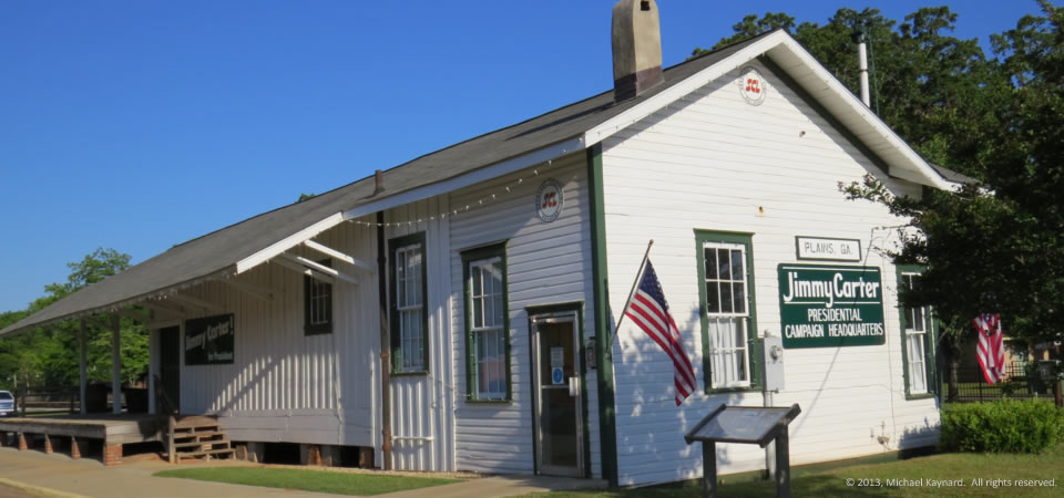
This old train platform in Plains, Ga., is preserved at the Jimmy Carter National Historic Site to highlight what an old train depot used to look like.  The other end of the building was the first campaign headquarters for Carter’s 1976 successful bid for the presidency.

We liked how the Park Service kept this part of the depot because it recalls simpler, slower times without all of the hustle and bustle of modern life (cell phones, computers, GPS, etc.)

Plains, about 15 miles west of Americus in Georgia’s agricultural heartland, had 776 people in 2010, according to the Census.  Three in five residents are black, with whites comprising almost all of the rest.  About a quarter of the population lives below the poverty line.

Photograph taken May 15, 2013, by Andy Brack, Center for a Better South.  Copyright 2013.  All rights reserved.

Campaign headquarters, Plains, Ga.

Carter campaign headquarters, Plains, Ga.  Photo by Michael Kaynard.
Carter campaign headquarters, Plains, Ga. Photo by Michael Kaynard.

In 1975 in this old train depot in Plains, Ga., former President Jimmy Carter started what some thought would be an unlikely presidential campaign.  The depot, now part of the Jimmy Carter National Historic Site, reportedly operated from 1888 to 1951 in this town of about 700.  Carter and his wife, Rosalynn, grew up in Plains.

Photographer Michael Kaynard noted, “There is a block of tourist businesses just down from the train depot Carter used as his campaign headquarters.  Other attractions include his boyhood farm, Plains High School, Billy Carter’s gas station, Rosalynn Carter’s family home and the private Carter compound. Some of the land is being used for agriculture but it would be bypassed except for its ties to the President and his family.”

Plains, whose public school system was absorbed into that of nearby Americus and Sumter County, had 776 people in 2010, according to the Census.  Three in five residents are black, with whites comprising almost all of the rest.  About a quarter of the population lives below the poverty line.

Photograph taken May 15, 2013, by Michael Kaynard, Kaynard Photography.  Copyright 2013.  All rights reserved.

Presidential classroom, Plains, Ga.

Classroom, Jimmy Carter National Historic Site, Plains, Ga.  Photo by Michael Kaynard.
Classroom, Jimmy Carter National Historic Site, Plains, Ga. Photo by Michael Kaynard.

Former President Jimmy Carter went to school in this Plains, Ga., classroom at Plains High School, now the museum and visitors’ center at the Jimmy Carter National Historic Site.

To our knowledge, this is the only federal presidential historic site in the Southern Crescent.  All over town, it’s easy to see commonalities with other rural communities across the Crescent — small-town life dominated by agriculture and a close-knit community.

Photographer Michael Kaynard noted, “There is a block of tourist businesses just down from the train depot Carter used as his campaign headquarters.  Other attractions include his boyhood farm, Plains High School, Billy Carter’s gas station, Rosalynn Carter’s family home and the private Carter compound. Some of the land is being used for agriculture but it would be bypassed except for its ties to the President and his family.”

Plains, whose public school system was absorbed into that of nearby Americus and Sumter County, had 776 people in 2010, according to the Census.  Three in five residents are black, with whites comprising almost all of the rest.  About a quarter of the population lives below the poverty line.

Photograph taken May 15, 2013, by Michael Kaynard, Kaynard Photography.  Copyright 2013.  All rights reserved.

Empty car dealership, Claxton, Ga.

Empty car dealership, Claxton, Ga.  Photo by Andy Brack.
Empty car dealership, Claxton, Ga. Photo by Andy Brack.

Claxton, Ga., known for its fruitcakes and annual rattlesnake roundup, is one of many rural Southern towns that features an empty, old car dealership.  In the background, you can see the town’s main stoplight at the intersection of Main and Duval streets, also known as the crossing of U.S. highways 301 and 280.

Some of the businesses in towns like Claxton moved out of the central business district to the outskirts to capitalize on Wal-Marts that drained downtown activity.  Some of them just closed.

Claxton, county seat for Evans County, is located about 50 miles west of Savannah, Ga.

While Claxton has about 2,200 residents, Evans County is home to an estimated 10,689 residents, a slight drop from the 11,000 people recorded in the 2010 Census.  Some 22 percent of Evans County residents live below the federal poverty level.  The average per capita income is $18,547.

Photo is from May 2013 and is copyrighted by Andy Brack, Center for a Better South.  All rights reserved.

Old one-room school, Montgomery County, Ga.


Old Memory Schoolhouse, Montgomery County, Ga., by Brian Brown.  All rights reserved.
Old Memory Schoolhouse, Montgomery County, Ga., by Brian Brown. All rights reserved.

This decaying, tin-roofed building apparently is a one-room school remembered as the old “Memory School” northeast of Mount Vernon, Ga., in rural Montgomery County.

Vanishing South Georgia photographer Brian Brown, who snapped the shot last month along Thompson Pond Road, says, “I first thought it looked like a farmhouse, but these small rural schools often look like this.”

These days, Montgomery County and the area around

ount Vernon seem strapped, but interestingly, the population is about 50 percent bigger than it was in the late 1960s when Brack visited.  In 2012, the estimated population was just under 9,000 — some 3,000 more people than in the 1970 Census.  More.

Some 21.6 percent of people in the county live at or below the federal poverty level.

Copyrighted photo by Brian Brown, courtesy of the photographer.  All rights reserved.

Old farmhouse, Montgomery County, Ga.

Old farmhouse, Montgomery County, Ga.  Copyright W. Brian Brown.  All rights reserved.
Old farmhouse, Montgomery County, Ga. Copyright Brian Brown. All rights reserved.

South Georgia photographer Brian Brown enjoys snapping pictures of old farmhouses on his great site, Vanishing South Georgia.  This board-and-batten farmhouse on the Mount-Vernon-Alston road in the Georgia heartland is typical, he writes on his site:

“This is one of the largest concentrations I’ve found of this iconic early South Georgia style.  …  I’d advise anyone who likes historic rural architecture who happens to be in the area of Montgomery County to find these roads. The structures located on them represent a quickly vanishing aspect of South Georgia’s agricultural heritage.”

These days, Montgomery County and the area around Mount Vernon seem strapped, but interestingly, the population is about 50 percent bigger than it was in the late 1960s when Brack visited.  In 2012, the estimated population was just under 9,000 — some 3,000 more people than in the 1970 Census.  More.

Some 21.6 percent of people in the county live at or below the federal poverty level.

Copyrighted photo by Brian Brown, courtesy of the photographer.  All rights reserved.

Old stores, Mount Vernon, Ga.

Old storefronts, Mount Vernon, Ga.

These two old buildings on Church Street in downtown Mount Vernon, Ga., caught the eye of photographer Michael Kaynard.  Both seem to be old stores. the left of which seems to be re-purposed as a hair salon.  The right one appeared empty.

Kaynard observed that people in Montgomery County seemed proud of the renovation of the county courthouse, which was nearby.  But in the square around the courthouse, there weren’t many active businesses.  “I spoke with a young woman in city hall and two of the businesses I asked about had been closed since before she arrived there” several years back, he said.

Georgia photographer Brian Brown of VanishingSouthGeorgia.com also enjoy these two Church Street buildings, saying here that they’re his two favorites in Mount Vernon.

These days, Montgomery County and the area around Mount Vernon seem strapped, but interestingly, the population is about 50 percent bigger than it was in the late 1960s when Brack visited.  In 2012, the estimated population was just under 9,000 — some 3,000 more people than in the 1970 Census.  More.

Some 21.6 percent of people in the county live at or below the federal poverty level.

Photo by Michael Kaynard, May 2013.  All rights reserved.

Montgomery Monitor, Mount Vernon, Ga.

Montgomery Monitor, Mount Vernon, Ga.

As a boy in the late 1960s, photographer and Better South President Andy Brack visited this building a few times a year because his father, Elliott Brack, published “The Montgomery Monitor” every week.

“I’d go with Dad as he made his weekly rounds to get the news to fill up this small paper,” Brack remembers.  “There was a nice older lady who worked there every day who would watch me for awhile.  On a lot of visits, I’d go across the street and get a haircut that would have passed any military inspection.

“It was fun riding to and from Mount Vernon and seeing all of the different scenes between there and our home in Jesup, some 75 miles to the south.  More than anything, those trips outside of Jesup contributed to a lifelong love of open, rural landscapes, like those found throughout the Southern Crescent, and the love of just traveling to see different things.”

These days, Montgomery County and the area around Mount Vernon seem strapped, but interestingly, the population is about 50 percent bigger than it was in the late 1960s when Brack visited.  In 2012, the estimated population was just under 9,000 — some 3,000 more people than in the 1970 Census.  More.

Some 21.6 percent of people in the county live at or below the federal poverty level.

Photo by Andy Brack, May 2013.  All rights reserved.

What’s this guy doing, Leary, Ga.

Videographer in Leary, Ga.

There’s not a lot that seems to go on in rural Leary, Ga., a southwestern agricultural village in Calhoun County.  So when a videographer shows up and starts filming local statues and buildings, people get to talking.  Unfortunately, the camera crew wouldn’t tell anybody why they were filming abandoned buildings, this statue, the old railroad stations and more.  Today’s photo is the fifth and last in a series that profiles what Leary looks like.

Leary, which had 610 people in the 2010 Census (56 fewer than 10 years earlier) is predominantly poor and black.  Three in four residents are black.  Some 36 percent of the people in Calhoun County live at or below the poverty line, according to the 2010 Census.

There’s not a lot of businesses in Leary.  Its train depot is closed.  Across the street from a busy convenience store is a full city block of deserted businesses and homes.  More than anything, Leary seems old and tired with little hope of a prosperous future.  Notes photographer Michael Kaynard, “The downtown area had been deserted and the jail, post office and other businesses moved away and followed the highway.”  Other than the store, the only thing that appeared to have some activity was a peanut plant, which operates seasonally.

Photo by Andy Brack of the Center for a Better South, May 2013.  All rights reserved.

Old station, Leary, Ga.

13.0613.leary4
Old railroad station, Leary, Ga.

The old railroad station in Leary, Ga., looks solid, but it’s slowly decaying, much like the rest of the small Calhoun County town is.  You can’t see it in this photo, but vines cover the back wall of the station.

Leary, which had 610 people in the 2010 Census (56 fewer than 10 years earlier) is predominantly poor and black.  Three in four residents are black.  Some 36 percent of the people in Calhoun County live at or below the poverty line, according to the 2010 Census.

There’s not a lot of businesses in Leary.  Its train depot is closed.  Across the street from a busy convenience store is a full city block of deserted businesses and homes.  More than anything, Leary seems old and tired with little hope of a prosperous future.  Notes photographer Michael Kaynard, “The downtown area had been deserted and the jail, post office and other businesses moved away and followed the highway.”  Other than the store, the only thing that appeared to have some activity was a peanut plant, which operates seasonally.

Photo by Andy Brack of the Center for a Better South, May 2013.  All rights reserved.