Sturdy, empty station, Olar, S.C.

Old, sturdy gas station, Olar, S.C.

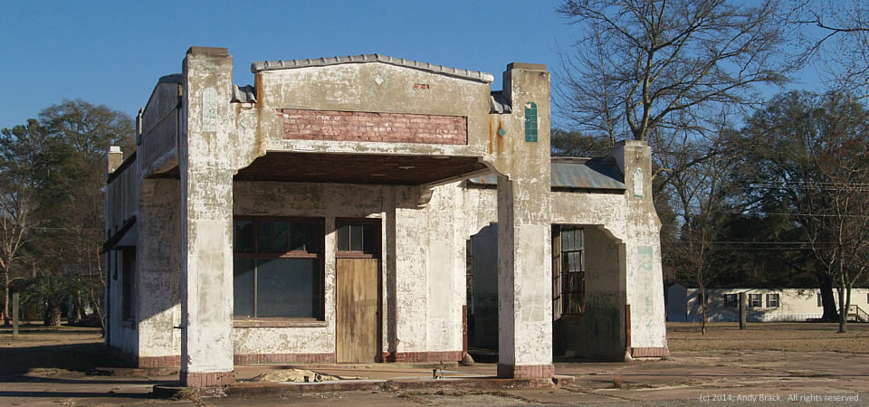
This gutted gas station in rural Olar, S.C., stands as a testament to sturdy buildings that litter the South along major highways in the days before the interstates.  The empty station looks like a perfect place for a movie set for a film of a time long past.

Situated along U.S. Highway 301 in the Bamberg County town of about 200 people, it’s not hard to imagine a booming business located here in the 1950s with big, American cars zooming by and locals stopping by for a Coca-Cola and bag of peanuts.  Across the street today is another abandoned gas station, competition from the past.

Bamberg County is home to about 16,000 people, 27 percent of whom live below the federal poverty level, according to 2012 Census estimates.  The majority of residents are black (61.4 percent) with whites comprising 36.8 percent. 

Photo taken January 2014 by Andy Brack.  All rights reserved.

Paradise Restaurant, Cooperville, Georgia

Empty Paradise Hotel, Cooperville, Ga.

The old Paradise Restaurant, which apparently suffered a fire in recent years, is closed, as is the gas station at right.  Both are adjacent to a spooky old motel featured on Halloween in this post.

The complex is in Cooperville at the intersection of U.S. Highway 301 and Georgia Highway 17 in Screven County, Ga., which got started after the Revolutionary War and soon became part of the Black Belt of Georgia where cotton became an important staple crop tended by enslaved African Americans.

The county’s population jumped from 3,019 in 1800 to 8,274 by 1860, according to Census figures.  While it had 14,593 people in 2010, the county lost an estimated 391 people — 2.7 percent — by 2012, according to the U.S. Census.  In 2010, Some 25.4 percent of county residents lived below the federal poverty level, 9 points higher than the state average.

Photo taken Sept. 23, 2013, by Andy Brack.  All rights reserved.

Deserted complex, Dunn, N.C.

Deserted tourist complex, near Dunn, N.C.  Photo by Andy Brack.
Deserted tourist complex, near Dunn, N.C. Photo by Andy Brack.

A tourist complex — motel, gas station and restaurant — are abandoned off an exit of Interstate 95 near Dunn, N.C., obvious victim to the recent recession.

The Southern Crescent follows the Interstate from the Tidewater part of Virginia around Emporia and across the Carolinas before it veers southwesterly near Savannah, Ga.  Millions of people live in these mostly rural, agricultural parts of the American South.  Distinguishing characteristics include high poverty rates, little new opportunities, struggling tax bases and high incidences of health problems.  See our maps on this site to get more perspective.

Dunn, which had a population of 9,582 in 2012, is rural enough to experience a high poverty rate — 27.5 percent — but is part of the Raleigh metropolitan area, which provides more opportunity for residents than in many Southern communities.  Raleigh’s influence is seen in how Hartnett County has more than 120,000 residents.

Photo taken July 21, 2013 by Better South President Andy Brack.  All rights reserved.